Universidade Federal de Santa Maria
REGET, Santa Maria, v. 23, Ed. Especial, e15, 2019
DOI: https://doi.org/10.5902/2236117038539
Submissão: 12/06/2019 Aprovação:
12/06/2019 Publicação: 27/06/2019

Natural characterization of the low course
of the Camaquã River in Cristal city-RS
Caracterização
natural do baixo curso do Rio Camaquã no município de Cristal-RS
Elissandro
Voigt BeierI
Cristiano
PoletoII
Maria
Eugênia Moreira Costa FerreiraIII
I
Doutorando
em Geografia, Departamento de Geografia, Universidade Estadual de Maringá,
Maringá, PR, Brasil. elissandrovoigt@hotmail.com
II
Doutor
em Recursos Hídricos e Saneamento Ambiental, Departamento de Engenharia
Ambiental, Universidade Federal do Rio Grande do Sul, Porto Alegre, RS, Brasil.
cristiano.poleto@ufrgs.br
III Doutora
em Geografia, Departamento de Geografia, Universidade Estadual de Maringá,
Maringá, PR, Brasil. eugeniaguart@hotmail.com
Resumo
Analisou-se
uma parcela do território rural do município de Cristal-RS, onde foram levantadas
as características naturais como pedologia, geologia, geomorfologia, rede
hídrica, climatologia e a biogeografia desta parcela geográfica. Para o
levantamento foram consideradas fontes bibliográficas como cartas topográficas,
mapas de levantamento do IBGE, fontes de referência como levantamentos
fitogeográficos e estudos aprofundados de dinâmica sedimentar e hidrológica que
trasnformaram a região no passado. Deste estudo foram levantadas
características específicas para cada uma das categorias de análise sendo
mapeadas em cartas específicas e analisadas em seu contexto de ocorrênica.
Resultando em uma caracterização das condições naturais da região, cujo cenário
atual, apresenta significativa diferenciação pela interferência antrópica no
meio.
Palavras-chave: Caracterização
natural; Bacia hidrográfica do Rio Camaquã; Paisagem fitogeográfica
Abstract
A
portion of the rural territory of the Cristal City-RS was analyzed in order to
assess the natural characteristics such as pedology, geology, geomorphology,
water network, climatology and the biogeography of this geographical area. For
the survey, bibliographical sources such as topographic charts, survey maps of
IBGE, reference sources like phytogeographic surveys, and detailed studies of
sedimentary and hydrological dynamics that transformed the region in the past
were considered. From this study, specific characteristics for each of the
analysis categories were mapped in definite charts and analyzed in their context
of occurrence. As a result, it was possible to characterizate the natural
conditions of the region whose current scenario presents significant
differentiation by the anthropic interference in the environment.
Keywords:
Natural characterization; Watershed of Camaquã River; Phytogeographic landscape
1
Introdução
The
study area and its environmental characteristics such as geology were
delimited: the pedology resulting from the decomposition of the rock, the
geomorphology, the geography conditioned by the climate and the water resources
that characterize these distinct spaces, besides the areas covered by the
vegetation and that are the result of the interactions between the natural
components, forming the environmental system of the region.
Cristal
is a municipality located in the south of the Rio Grande do Sul State and it is
considered small according to the classification of the Brazilian Institute of
Geography and Statistics (IBGE, 2016). It has a territorial unit area of
681,625 km², with an estimated population of 7,792 inhabitants, predominantly
urban, although it is important to consider that the local economy is based on
rural production.
The
municipality is in the south of the Rio Grande do Sul State and it is located
between the coordinates 30°52'59" S, 52°14'55.8" W; 31°07'17.3"
S 51°47'24.1" W, being fully inserted in the Camaquã river basin,
specifically in the low river course.
The
area has transitional environmental characteristics conditioned by geology,
geomorphology and local geography, which resulted in a diversity and overlap of
species of two different natural systems, to the east the internal lagoon
plain, and to the west the southeastern mountain range, a region that requires
the understanding of its particularities.
The
study area presents approximately 36 km2 which is divided in two sets that
present distinct characteristics and overlap in geological, geomorphological,
pedological and biogeographic aspects and also in the use and occupation of the
soil in the present day.
The
research area is located in the northwest quadrant of Cristal City-RS and it is
shown in Figure 01. The territory has as limits to the north, northeast and
east the margin of the Camaquã River; to the south and southwest, the road from
Sapata which connects the seat of the municipality of Cristal to the
municipality of Canguçu and, as a delimiter in the west quadrant, there exists
the rural road linking the interiority of Butiá to the municipality of Amaral
Ferrador located on the left bank of the Camaquã River.
The
entire research area is in a rural, agricultural and intense mechanized
context, with a differentiation of the division and occupation of the soil
conditioned by the immigration process and the different natural conditions of
the region.
The
Northwest sub-region of the research area corresponds to the steepest area,
with granite outcrops and small farms occupied by late European immigration;
and a second area in the SE quadrant where there are large rural properties
with a lower degree of slope, with almost no existence of rocky outcrops. The
latter, it was the product of the appropriation of allottees and descendants of
Spaniards and Portuguese in the first movements of Europeans in the region and,
due to the natural characteristics, propitiated the agriculture of large scale
and fields of extensive creation.
The
soil use through agricultural practices such as intensive mechanization and
other practices that require direct interference such as earth-moving
processes, large-scale removal and inversion of soil, and road construction are
some of the major processes that cause deterioration and loss of the
archaeological and cultural heritage in the region of study, as identified
during the bibliographic reference.
Human
activities, in general, alter and interfere in the stratigraphy of the sites or
in environments with the presence of cultural patrimony (HOFMAN, 1986; KELLY,
1992).
For
the area composed of small rural properties, which covers the region of the
edge of the Southeast, a great concentration of archaeological sites was
identified; the second region differentiated by land occupation, with large
rural properties, presents a lower density of archaeological sites identified
(SOCIOECONOMIC ATLAS, 2002).
For
the area composed of small rural properties which covers the region of the edge
of the Southeast mountain range, a great concentration of archaeological sites
was identified; the second region differentiated by land occupation, with large
rural properties, presents a lower density of archaeological sites identified
(SOCIOECONOMIC ATLAS, 2002).
Figure 01- Representation of the study area
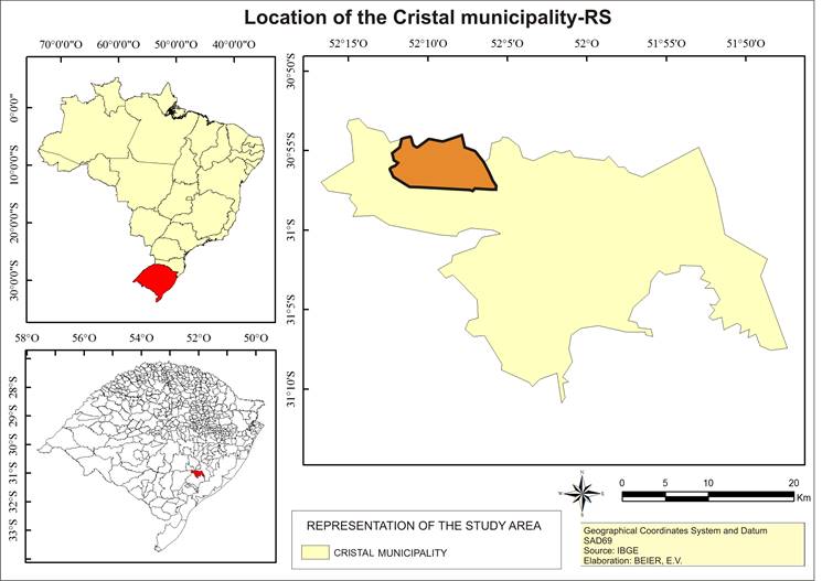
Source:
BEIER, 2017
2 Environmental Characterizations of the Lower Valley
of the Camaquã River
Some
natural features that shape and interfere with the landscape have been
considered. These characteristics have modified the environment over geological
time and, observing the area, it is easier to discuss these characteristics
through the morphology of geographic space and the appropriation of the same by
the man from the past to the present.
2.1
Geology
Like the pedoturbation discussed earlier, the components of the site,
artifacts or products produced by human intervention in the course of an
occupation are analyzed here from a theoretical point of view.
The rocks used by the paleoindigenous people in the manufacture of
instruments are almost always available in outcrops, products of mechanical
weathering and river transport, having being transported from distant original
areas and deposited along the course of the river.
These outcrops are expressed by deposits of rolled pebbles, forming
marginal banks with sand deposits (beaches) or exclusive (banks of pebbles)
which, for this reason, form privileged sources of raw material (PROUS, 1986;
1990).
This phenomenon can be observed in the study area, considering that most
of the lithic material identified in the sites comes from lithology external to
the lithology of the study area. In doing so, it should be considered that the
springs and the upper and middle portion of the course of the Camaquã River are
located in a geological region distinct from the area of the low course where
the study area is located.
The portion of the upstream territory is partially inserted into the
sedimentary basin of the Camaquã River, which presents different
volcano-sedimentary associations representative of the transition stage of the
South American Platform (ALMEIDA, 1969, apud PEREIRA, 2011, p.24).
These sedimentary lithologies provide coarse sediments when affected by
mechanical erosion, transporting them from the upper parts of the basin.
Furthermore, rocks such as andesites, slate, quartzites, fine and coarse
sandstones, conglomerates, argillites and rhythmites are identified in the
upper course of the river (PEREIRA, 2011).
Within the geological contex, the área can be divided in two, having the
Crystalline Shield or Crystal Basis to the north and the Internal Alluvial
Plain composed by the quaternary sediments to the south and east, classifying
the distinct spaces by their natural and anthropic characteristics.
The geology of the region is described in the Program of Basic Geological
Surveys of the Brazilian Geological Service (SGB) in conjunction with the
Company of Research of Mineral Resources (CPRM) and the area of interest of this
study is installed predominantly on the Pre-Cambrian and Cambrian rocky massifs
of the Dom Feliciano Orogenic Belt (ROISENBERG, 2007).
The shield is composed of rocks of varied ages from the Archaean to the
Epochal. It presents associations of metamorphic rocks, igneous and sedimentary
of diverse age, origin and evolution, distributed in a complex
tecno-stratigraphic arrangement controlled by regional lineaments of
predominant NE-SW and NW-SE orientations (ROISENBERG, 2007).
Characterizing the north-northeast portion, there exists the granite-gnassic
basement represented by the Canguçu Complex (Figure 02) representing the
pre-Cambrian unit in the region. As examples of the Cambrian, it can be cited
the granite suite Arroio dos Ladrões (ROISENBERG, 2007).
Bordering these lithologic units, there is the second part of the
territory with varied sedimentary littoral from the Quaternary Tertiary age
represented by the Guaxaim, Chuí formations and the estuary deposits
(alluvial, lacustrine, eolic, marine, colluvial, present and subpresent)
(ROISENBERG, 2007).
It comprises the internal alluvial plain or deltaic fluvial plain
characterizing the adjacent sediments of the basement and deposited at its base,
and the Pleistocene and Holocene lagoon deposits (Laguna Barreia System I, II,
III and IV) dominated by deltaic fan systems (Fan Deltas), having as the main
source rocks the lithology of the basement, and secondarily, the own deposits
of this system, through cyclic reworking along the Quaternary, since its distal
structures were reworked in a marine and later in a lagoon environment (
TOMAZELLI and VILLWOCK, 2000).
It is formed the alluvial fan systems located adjacent to uplands or
water bodies, generating a complex of environments and sub environments
(fluvial, paludal, lagoon, praial and marine) (BITENCOURT, 1992).
In doing so, it is considered the sea-level oscillations and the
influence of marine transgressions and regressions for the region from the lower
Pleistocene and Holocene (VILLWOCK et al., 1986).
It is contained in this latter formation of unconsolidated sediments such
as alluvial, sands, gravel and silty-clayey of flood plains deposits.
According
to Bitencourt (1992, p.35):
Throughout the coastal plain,
alluvial fan systems are generated from upland slopes, initially by
gravitational mass movements, gradually moving to alluvial systems
characterizing easy eluvial and colluvial, mid-slope regions, and easy alluvial
regions in the lower regions. Conglomerates, diamictites, sandstones and
argillites constitute the lithologies of the region.
Villwock and Tomazelli (1995) describe the formation of the coastal plain
for the region as formed by alluviums, colluviums and alluvial fans developed
at the base of the slopes of the shield and Barrier I (Figure 03), including
tertiary deposits in the valleys of the main water courses.
Alluvial Fan Depositional Systems are the result of dominantly
gravitational processes such as the free fall of blocks, crawling and the flow
of debris and that transverse, in the extreme portion, to sediments transported
and deposited in aqueous media (alluviums) (TOMAZELLI and VILLWOCK, 2000).
Figure
02 - Geology representation for the study area
Source: Adapted
from IBGE (2003)
Still, according to Tomazelli and Villwock (2000, p.40), "There is
strong evidence that fluctuations between arid and moist climates that occurred
in the Upper and Quaternary Tertiary had great influence on the development of
this depositional system." Considering the climatic variations and the
implications on precipitation rates and the development of the vegetation cover
on the shield
2.2
Geomorphology
The study area presents varied geomorphological features considering the
different lithologies, modeling processes and climatic conditions that occur
over time.
According to Tomazelli and Villwock (2000, p.40), "Internal Alluvial
Plain corresponds to the strip of land that extends between the highlands of
the Sul-Rio-Grandense Shield and the large bodies of water of the Lagoon
Patos-Mirim System." They are lands slightly sloped to the east where rounded
coxillas of the borders of the shield give place to terraces dissected by the
current drainage.
The
crystalline shell or basement has a relief dissected by erosive agents, forming
undulating slopes between the heights of 60 m and 90 m, changing the landscape
to strongly undulating slopes in heights higher than 90 m, reaching a maximum
dimension of 212 m.
According to Bittencourt (1992, p. 92), "In high regions, the slopes
exhibit convex shapes, and in depressed regions (valleys or depressions) they
exhibit concave forms where rocky blocks frequently appear."
Specifically,
the study region is classified as being from the Canguçu-Caçapava Residual
Plateau; Marginal low plateau, corresponding to a classified portion (North-Northwest
portion), area with higher altitudes with a maximum topographic elevation of
212 meters of altitude and more pronounced slopes (STESA, 2010).
And a second portion identified as Internal Alluvial Plain;
fluvial-deltaic plain (Eastern-Southeast portion), the morphological features
that form part of this territory constitute the deltaic plains (swamps, lakes),
fluvial channels (distributive channels, abandoned meanders), slightly sloping
large fluvial terraces (marked by the edge of terraces) (BITENCOURT, 1992).
In this portion, the dimensions vary between a minimum of 19 meters and
60 meters approximately, where the relief presents smooth to wavy forms
characterized by the small degree of inclination, with quite dissected slopes
and notched by fluvio-delta systems implanted after its formation (BITENCOURT,
1992).
2.3
Climatology
The
climate for the region is classified by Köppen (1936) as Cfa (temperate humid),
subdivision of the general classification Cf (temperate climate), which results
from regions with humid climate, when precipitation is well distributed in all
months of the year without the existence of a defined dry season (as summarized
in Table 01 and observed in Figure 04).
According
to Köppen-Geiger (2007, p.01), "The classification is based on the
assumption, originating from phytosociology and ecology, that the natural
vegetation of each major region of the Earth is essentially an expression of
the prevailing climate."
Figure
03 - Representation of the portion of alluvial fans
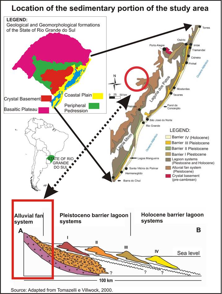
Source:
Adapted from Tomazelli and Villwock, 2000
Table 01 - Climatic classification for the
study area
|
C
|
·
Mesothermal
climates;
·
Average
air temperature of the coolest 3 months between - 3 °C and -18 °C;
·
Average
temperature of the hottest month > 10°C;
·
Well
defined summer and winter seasons;
|
|
f
|
·
Humid
climate;
·
Occurrence
of precipitation in all months of the year;
·
No
defined dry season;
|
|
a
|
·
Hot
summer;
·
Average
air temperature in the hottest month> 22 ° C.
|
Source:
Adapted from Köppen-Geiger (2007)
According
to Rossato (2011), the average relative humidity of the air during the year for
the region is concentrated in 79%, not showing great variation in the different
seasons of the year.
Furthermore,
still as stated by Rossato (2011), rainfall averages do not show large
oscillations during the year, with a history of concentrations of 400 mm in
spring; 400 mm in summer; 350 in the fall and the maximum of 450 mm in winter,
having a history of 1,600 mm / year.
Besides,
it also occurs in the winter the lowest rates of solar radiation, considering
the highest periods with clouds. They revolve around 80-100 days days with
precipitation for the region, distributing 6-9 days on average for monthly
precipitation. Average annual temperatures range from 17-20 ° C. The study area
presents higher values during the summer, specifically in the month of January
with 20-26 ° and in the month of July, during winter, the minimum averages of
11-14 ° C are presented (ROSSATO, 2011).
Winters
are cold, with polar systems and less participation of tropical systems. In addition,
the frontal systems are responsible for the highest rainfall concentrations
throughout the year, considering the precipitation history for the winter.
The
predominant atmospheric systems in the region correspond to the Antarctic Polar
Mass (mPa), which is more active during the autumn and winter months,
preferentially entering the south-southwest border, specifically along the
border with Uruguay and Argentina, sometimes affected by rigorous winters due
to the Pacific Polar Mass (mPp) with characteristics of dry and cold climate;
At times, it has dry and hot characteristics with convective precipitation,
being characterized by the incidence of hot North winds (mTc); Associated with
the anticyclones of the South Atlantic, it acts with characteristics of hot
conditions on a great part of the coast and the continent (mTa).
Figure 4 - Climatic classification
for the study area

Source: Adapted from
Rossato (2011)
2.4
Pedology
It
is common for soils to derive directly from lithology and that the region has
granite formation. The soils formed in this environment are not very thick in
general, but are distinguished considering the topography and the relief, with
a pedological formation in the topographic areas, with rocky outcrops and a
differentiated pedological formation that results from the weathering of the
source rock transported and deposited at low levels along the geological time,
forming the quaternary alluvial fans, as shown in Figure 05.
The
soils formed do not present very expressive profile, the mountainous region
having a formation of horizons A, being very quartz, well drained, clayey,
little fertile naturally and with regolith with shallow depth.
According
to IBGE (2003), there is a complex association of dystrophic lithographic soils
with medium chalky texture; Cambisols dystrophic medium chalcky and clayey
textures; Podzolic red-yellow dystrophic with medium / clayey texture; Podzolic
Bruno grayish dystrophic and eutrophic medium / clayey texture with strong
undulating relief and rock outcrops.
The
less sloping region presents deeper, alluvial, colluvial and very clayey soils
with a lower rate of quartz (BRAZIL, 1973).
According
to IBGE (2003), for the organization of the region, it is proposed the
classification of dystrophic Red-yellow Podzolic soil, argisol in which the
base saturation is 50% with average low fertility.
They
are characterized by medium-textured clayey sediments in wavy relief and
average sandy texture in flat relief (IBGE, 2003).
In
the region of alluvial fans are also found Planosol soils; Eutrophic Planosol
and Eutrophic Gleysols. Because it represents the lowest part of the residual
alluvial fan, it presents accumulation of excess water, with medium sand-clay
texture and medium clay texture in the flat relief.
When
its chemical composition is altered and it becomes acidic with a typical light
color by the continuous location of water on it, it becomes less productive for
many crops. Therefore, it used instead for grazing and eventual winter crops,
being necessary the acidity correction of the soil (EMBRAPA, 1997).
From
this differentiation of lithologys, results the variation of land uses and
management for the region concentrating maize and tobacco in the upper and steepest
part of the area and subsistence crops in small plots of the land, thus
considering the outcrop of blocks of granite.
On
the other hand, in the flat region, the soil is uninterrupted due to
lithological issues and the extensions of crops extend beyond the horizon.
Therefore, the landscape is quite altered and even the smallest watercourses
are renewed and altered with rectifications for its maximum exploitation in
what concerns the expansion of soybeans, maize and, mainly, irrigated areas for
rice-growing.
Figure
05 - Pedological classification for the region
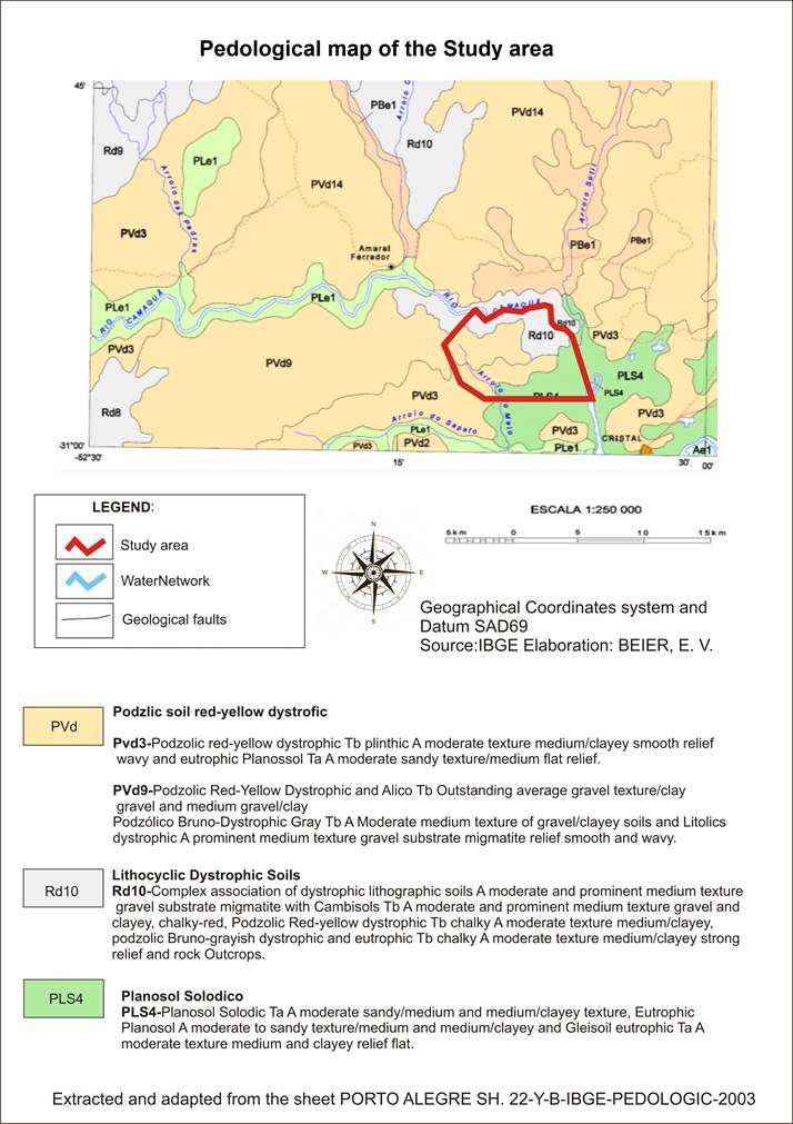
Source: Adapted
from IBGE (2003)
2.5
Water resources
River
drainage is composed of a set of interrelated flow channels that form the
drainage basin, or river basin, defined as the area drained by a given river or
by a river system (CHRISTOFOLETTI, 1980).
The
area is located on 18 distinct micro-basis with small and medium dimensions
which drain directly to the Camaquã River and to the secondary drains of the
basin (the Passo do Meio stream and the Sapata stream).
The
watershed of the Camaquã River is classified as rivers that present drainage
directly to the sea, when the drainage of its waters is made continuously to
the sea or ocean, that is, directly into the sea level, as defined by Christofoletti
(1980), and the exuvial of the basin on the right bank of the Patos Lagoon.
The
study region represents only a small fragment inserted entirely in the
catchment area of the Camaquã River and presents a hydrological labyrinth
composed by micro-basins and streams of smaller hydrological capacity of drainage
and of small proportion, the small streams (the water mesh can be observed in
Figure 06).
According
to Oliveira (1980, p.502), small streams corresponds to an intermittent stream
in the southern region of Brazil. In the IBGE (2010, p.29) conceptualization,
“sanga” means small stream that dries easily, a small stream of water, in
general, a water drain used in Rio Grande do Sul State.
Regarding
the classification, based on the consistency of flow, Oliveira (1980) and IBGE
(2010), conceptualize the small streams with intermittent behavior, although in
practice this behavior may not be a rule. When water courses were observed
during the period of the research, the flow behavior of these rivers is in the
perennial classification. According to Villela and Mattos (1975, p.12), these
watercourses contain water at all times, the underground sheet maintains a
continuous feed and never descends below the bed of the watercourse, even
during the most severe droughts.
Christofoletti
(1980) classified the watercourses in a genetic way, considering them in
relation to the slope of the geological layers. Analyzing the drainage network
for the delimited research fragment, we observed the establishment of a network
called insequent rivers, and these courses are established when there is no
apparent reason to follow a pre-established general orientation, that is, when
no control of the geological structure becomes visible in the spatial
arrangement of the drainage. The bodies of water flow according to the
particularities of the morphology, in varied directions. They are common in
areas where the topography is flat and in areas of lithological homogeneity like
in the granitic or igneous areas, as was shown the lithology in the study area.
The
classification of the small streams based on the morphology of the channels for
the study area, occurs in relation to the morphometric parameters. In this way,
we delimit the channels as being rectilinear, morphologically described as
single channels with longitudinal bars.
The
analysis of the drainage patterns refers to the spatial arrangement of the
fluvial courses, which can be influenced in their morphogenetic activity by the
nature and arrangement of the rock beds, by the different lithological
resistances, by the differentiations in the slope of the terrain and by the
transformation of the geomorphology of the region (CHRISTOFOLETTI, 1980,
p.103).
Regarding
the fundamental types of drainage patterns and their occurrences for the study
region, they can be classified, according to Christofoletti (1980):
•
Dendritic drainage: Also referred to as arborescent, since its development
resembles the structure of a tree, where the channel of the main stream
characterizes the trunk and the tributaries configure the branches and these
are dispersed in all directions of the surface of the land. This pattern
develops on rocks of uniform resistance like the granite complex. And the rivers
that constitute this pattern form confluences at acute angles of varied
gradations, with rare confluences at right angles to this pattern and, when
they occur, are due to tectonic anomalies (faults, joints or diachras).
The
river hierarchy refers to the order of the water courses, corresponding to the
degree of bifurcation and branching between the channels within the basins, for
the geographic clipping used in the micro-basins analyzed. The determination of
the order of the rivers, besides indicating their degree of branching, helps in
the morphological analysis of the watershed (BACK, 2014, p.74).
The
criterion for classification was proposed by Horton in 1945 (HORTON, 1945) and
modified by Strahler (1957). According to the classification proposed by
Strahler, this one eliminated the subjectivity of the Horton criterion that
started from the designation of the main river from the nascent to the exudory
with the same order number, among other peculiarities that the method of Horton
had adopted.
Figure
06 - Drainage network of the study area

For
Strahler (1957), the criterion could be explicitly simpler, in which the
smaller and unbranched tributaries are classified in the first order and the
union of channels of the same order (i) form a channel of order (i + 1). When
different order channels come together, the subsequent channel remains with the
larger of these two orders. Strahler's proposal eliminates the concept that the
main river should have the same order number in its entirety and the necessity
of re-numbering at each junction of a new tributary.
The
physical characterization of hydrographic basins refers to, among other
characteristics, the size, shape and slope that influence the hydrological
behavior of these hydrographic basins. The flow volume, peak flow and water
outflow velocity of the basin and the flow time and sediment transport are
directly related to the physical characteristics of the basin.
Even
though the studied watersheds are in a context of anthropization and a strong
alteration in the landscape, contributing to the sediment load by the
activities developed there, these variables were not analyzed in this study.
2.6
Biogeography
The
biogeography of the region is considered to be diversified, phytogeographically
presented as a transition environment, with plant species of Submontane Semidecidual
Seasonal Forest in the southeastern mountain range and the Alluvial
Semi-deciduous Seasonal Forest, commonly known as gallery forest, or riverine
forest, in the lower part, flat and prone to flooding during flood periods of
the river.
According
to Schimper (1898), who was an exponent of phytogeography, there are two large
groups of plant formations: climatic and edaphic. It can be said that the
proper formation of Rio Grande do Sul is a Subtropical forest of climatic
order; variations are due to the soil; the systematic composition is a result
of the temperature (RAMBO, 2015).
Still
according to the plant formations of the study area in the low-end portion,
along with (WAECHTER and JARENKOW, 1998), considering the pedological,
geomorphological and climatic conditions, it has a lower floristic richness
compared to the northern regions of the Coastal Plain itself and other areas in
the state.
With
the soil saturated most of the time, conditioned to floods by the
geomorphological conditions, by the periodic floods that also collaborate for a
reduction in the floristic diversity, selecting and restricting the species
that can occupy the riverside environment (BERTANI et al., 2001), by the environmental
dynamics provided by the interaction of the soil with the river, there is a
dynamic of environments and a heterogeneity that favors the implantation of
select species (MANTOVANI, 1989).
For
the slopes of the southeastern mountain range, the vegetation cover has a
forested structure, being directly linked to soil conditions, conditioned by
the weathering of the granite, and thus the same is responsible for the
formation of the natural landscape of the Southeast Mountain Range (RAMBO,
2015). Many laterite areas appear and this, unlike clay, does not offer necessary
materials to the plants, a phenomenon that is the explanation for the
occurrence of the vegetation of the Southeastern Mountain Range being scarce
and creeping on laterite surfaces (RAMBO, 2015).
Another
important determinant, for the primary forest sites is that they do not have
expressive docile on the slopes and high topography areas and there exists high
abundance of rocky outcrops found on the slopes of this region, provided by
physical weathering (JURINITZ and JARENKOW, 2003).
According
to (KER et al., 1986), they are from shallow to deep soils characterized by the
presence of a reddish-yellow textural B horizon. Complementing the
classification, Tomé Júnior (1997) classifies this soil as having a medium
texture with low to moderate susceptibility to erosion, presenting average
levels of organic matter and very low pH.
2.7
Fauna
The
flat area environment results in a great wealth of species since it offers a
great variety of habitats for the vegetation and, as a consequence, offers
places of shelter, reproduction and feeding for the fauna. In this environment,
there is the broad-snouted caiman (Caiman latirostris), winter concentrations
of Anatidae (mallards and swans) and Rallidae (Fulica spp. and Gallinula
chloropus, woodcocks).
2.8
Flora
Some
Araucaria enclaves were recorded on the slopes of the Caçapava do Sul massifs
(AB'SABER, 2003, p.22). Still according to Behling et al. (2016), by means of
palynological studies, the same possibility was verified. Thus,it was found as
punctual occurrences cactaceae, apparent relics of a drier paleoclimate of the
Upper Pleistocene.
This
system, which is not unlike the rest of the environment, has been losing its
natural characteristics due to the changes caused by anthropic occupation, such
as drainage of floodplains and plains for irrigation and cutting of the forest
and owing to agricultural or pastoral use. The removal of herbaceous and
shrubby vegetation from the banks of the Camaquã River and its riparian
environments provoke strong erosion of the banks, with the fall of the ravines,
resulting in an expressive loss of portions of the forested land which results
in visible siltation (BORGES-MARTINS, 2007).
The
riparian vegetation that marginalized the "sangas" was extremely
devastated, determining slight nesting ravines and a strong acceleration of
fluvial erosion (AB'SABER, 2003, p.22).
According
to an analysis by Rambo (2015), the mountainous part presents a natural and
anthropogenic stratification that can be classified as forest (from shrub
vegetation to tropical forest) and meadow (steppe, prairie and field).
Also
along with Rambo (2015), this part of the territory can be divided into four
distinct formations. From this total, it was possible to group some sets,
considering the characteristics of the vegetation resulting in four groups:
Fields (clean and dirty); Barns (regenerating forest, primary stage);
Regenerating forest (secondary stage); Adult forests (developed stage that
includes isolated capons and gallery forest). The arboreal composition of the
study region can be observed in figure 07 and it was described below:
a)
Clean field: interspersed with many granite
blocks discovered or semi-buried with vegetation of grasses and composts, being
no more than half a meter high.
Dirty
field: covered with carquejas (Baccharis), bushes of tall grass. It develops in
very flat areas or where the soil has deeper profiles. It can be found species
like Palm (Opuntia monacantha), the tuna (Cereus peruvianus) and grass of the
species Andropogon and Baccharis psiadioides.
There
are many points with granite outcrops in large blocks of tens of meters of
height and that concentrate a specific vegetation of environment without
pedological cover such as lithophytes, round cacti in the shape of a hedgehog
(Echinocactus), columnar tunas (Cereus), gravy (Dyckia) and an infinity of
crusty and foliaceous lichens;
b)
Brooms: formed of shrubs of up to 03 meters high which consists most of the
red-broom (Dodonaea viscosa) and the bush species of common brooms (Baccharis)
are mixed with the dirty field. At this stage are common: common broom
(Baccharis dracunculifolia), wild tobacco (Solanum mauritianum) and several
species of Eryngium. Shrub or subarborescent mats with the greatest
significance for the hard and contorted shrubs of the myrtaceous family,
spittle sarsaparilla weeds (Smilax); bignoniaceous and others; This formation
constitutes the upper limit of the closed jungle vegetation, butis (Butia
capitata);
c)
Arborescent or tall bush containing (Fagara), Chalchal (Allophylus edulis),
horse whipping (Luhea divaricatar), coconuts (Erythroxilum), cinnamons
(Nectandra), black heart (Maytenus cassineformis), willow (Salix humboldtiana),
baillon (Sebastiania commersoniana), vegetation of vines with species belonging
to the bignoniaceae, liliaceae, malpighiaceae and passifloraceae families; the
tallest trees are covered with epiphytes, woody beards (Tillandsia usneodis),
orchids, ferns and piperaceae.
Bushes
formed by specimens of common acrylate (Lithraea brasiliensis), aroeira parsley
(Schinus molle), capororoca (Myrsine umbellata), tea bugre (Casearia
sylvestris), red cambodia (Cupania vernalis Cambess), howler monkey (Dalbergia
frutescens) and grandiuva (Trema micranta) which is quite common in all
environments.
d) Capons,
clearly detached from the forest with a closed structure are located along the
springs on the slope. Among some of its specimens, it can be mentioned Guabira
(Campomanesia xanthocarpa), Jerivá (Syagrus romanzoffiana) and Machaerium
stipitatum.
A
gallery forest which accompanies the watercourse starting sub-shrubs at the
sources, developing into little nurseries on the dry and rocky slopes, and
ending in regular range forests, diversifying according to the volume of water
and alluvium.
Virgin
woodland that resembles the subtropical forests of the plateau regarding the composition.
It is along the Camaquã River, as well as in the more voluminous arms, with
vegetal species that reach large size like Timbauva (Enterolobium
contortisiliquum), Laurel (Cordia trichotoma), Canjerana (Cabralea canjerana),
Cedrella (Cedrella fissilis), Canjerana (Cabralea canjerana), Ipe (Tabebuia
chrysotricha), Angico vermelho (Parapiptadenia rigida) and Pinheiro-bravo
(Podocarpus lambertii).
In
the flattest area, which is composed of fields with natural characteristics, it
corresponds to the largest area for this sector, in a smaller plot. It also
presents a naturally sedimentary environment with swamps, lagoons, beach
deposits and abandoned meanders.
In
swampy environments, marshy vegetation presents floating types with no
terrestrial roots, such as the Aguapes (Eichhornia crassipes) with beautiful
blue inflorescences (Salvinia auriculata and Azolla filiculoides) and species
like Wolffiella and Lemna as well as families such as Lemnaceae and Pontederiaceae;
species of submerged rhizome and leaves extended in the air like Leather Hat
(Echinodorus grandiflorus), other species found in the loamy margin such as
Heteranthera and various grasses, Hydrocotyle, the sorrel of the species
Oxalis.
In
the parts where the fields prevail, the vegetation finds a hard and dry soil.
In the field areas, the vegetation cover was thin and low formed in its great
mass of grasses and cyperaceae. The common grasses of the Rio Grande fields,
such as Andropogon leucostachyus, Cenchrus tribuloides, Paspalum, Fimbristylis
complanata, Kyllinga pungens, Hydrocotyle umbellate and Centella asiatica
coexist in concomitance with Hyptis labiadas, Solanum sisymbriifolium,
Eryngium nudicaule, Macrosiphonia longiflora , the Pampas grass (Cortaderia
selloana), a good number of species of Panicum, Paspalum, Eriathus, Andropogon,
Baccharis (Carqueja), certain grasses of the genus Erianthus, Elionurus e Anana
(Ananas bracteatus) as well as pteridophytes of the genus Pteris, Gleichenia and
Lycopodium.
Many
grasses, such as cyperaceae, iridaceous, leguminous, umbelliferous and the
small Aristolochia sessilifolia, the leaves are reduced to rudiments as in many
verbenaceae of the genera Verbena and Lippia and there is also the common broom
Baccharis dracunculifolia with strong aromatic smell.
On
the wet banks of the lagoons and in the forest areas on dry land species such
as (Erythrina cristagalli) that always line the waterways, the willow by the
edge of the water (Salix humboldtiana), the Sarandi on the edge of the river
(Sebastiia schottiana), Terminalia australis, Ficus cestrifolia, Syagrus
romanzoffiana, Bromelia fastuosa, Cedrela fissilis, Gleditschia amorphoides,
Yellow araça (Psidium cattleyanum), angico (Parapiptadenia rigida), claw of the
cat ( Acacia bonariensis), camomile (Myrciaria tenella) and other species of
Myrtaceae such as bronquilho (Sebastiania commersoniana), bull shade
(Acanthosyris spinescens), aroeira brava (Lithraea brasiliensis), representing
vines and lianas (Bignonia sciuripabula) besides the straight and white curls of
Escallonia bifida.
Most
of the typically country plants have closely united inflorescences, chaplets
and condensed ears. This arrangement has a dual purpose: first, by the intimate
union of flowers, the effects of the sun are reduced; second, by the cluster of
many small and minimal flowers, they result in showy inflorescences, easily
identified by pollinating insects (RAMBO, 2015).
Figure 07 - Vegetable composition of
study
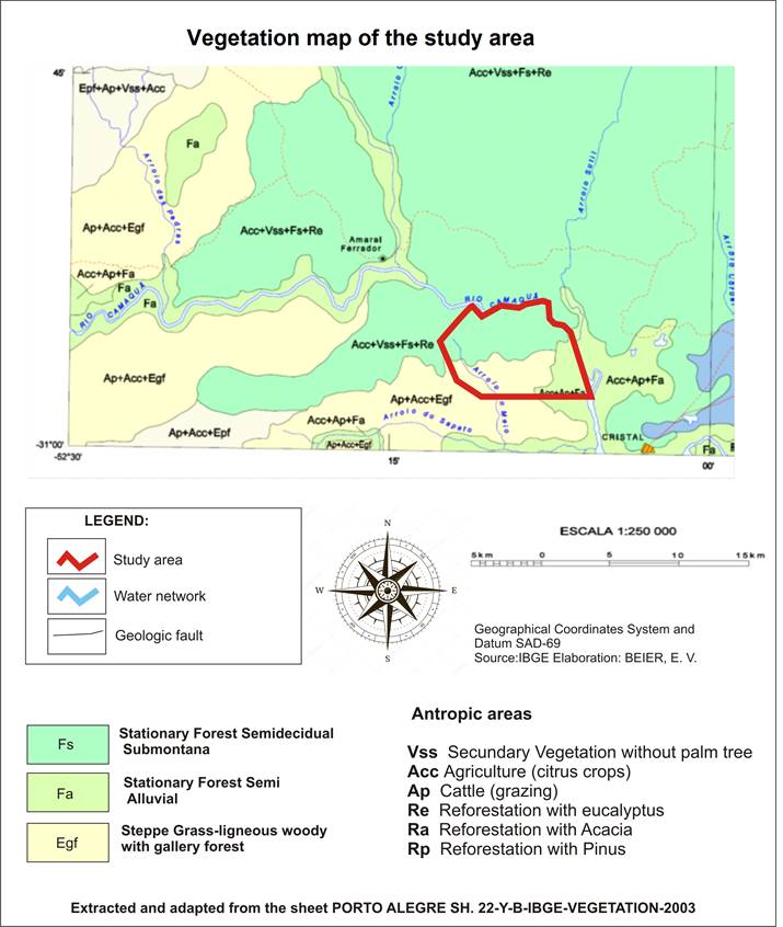
Source: Adapted from IBGE (2003)
Currently,
the number of portions of the territory converted to silviculture, bracatinga
(Mimosa scabrella, eucalyptus, various species) is increasing; black acacia
(Acacia mearnsii) and pinus (Pinus elliottii). These last three, by their ease of
natural dispersion become invasive, affecting naturaland and regeneration
areas.
3 Final considerations
The
study proposed the environmental characterization of the delimited area, considering
different environmental components. This investigation was considered analyzing
the disposition of the natural elements in the landscape and its delimitation
in the space.
It
is concluded with this analysis that the natural characterization of the region
has a close connection with the variables that shape and transform it such as
climate, geology and pedology resulting in a specific phytogeographic
classification adapted and a water network imposed by the climate and by
geology resulting in rivers always fed hydrically.
It
was also observed a diverse flora and fauna conditioned by geological,
geomorphological and climatic formation resulting in a diversified and dynamic
environment with overlapping species of two distinct environments.
Environmentally,
the characterization of the region is altered by anthropogenic actions
revolving the soil, rectifying the water network and predating the native flora
and fauna for the imposition of specimens and activity that require management
and mechanization.
Acknowledgment
The Capes, for incentive research, to the reviewers
contributing to suggestions and improvements.
References
AB
'SABER AN. The domains of nature in Brazil: Brazilian landscape potential. Ateliê
Editorial: São Paulo; 2003
BACK AJ.
2014. Hydrographic basins: Classification and physical characterization (with
HidroBacias program for calculations). Florianopolis, Epagri. 162p.
BRAZIL. Ministry
of Agriculture, National Department of Agricultural Research, Division of
Pedological Research. Survey of Soil Recognition of the Rio Grande do Sul
State. Rio de Janeiro, p. 431, 1973.
BEHLING H et al, Late Holocene
Vegetation History and Early Evidence of Araucaria Angustifolia in Caçapava Do
Sul in the Lowland Region of Rio Grande Do Sul State, Southern Brazil. [cited
2018 fev 12]; Braz. arch. biol. technol. vol. 59. Curitiba: 2016, Epub, Apr 29. Available from: http://www.scielo.br/pdf/babt/v59/1516-8913-babt-16150264.pdf.
BERTANI DF, Rodrigues RR, Batista JLF, Shepherd, GJ.
2001. Temporal
analysis of floristic and structural heterogeneity in a riverine forest. [cited 2018 fev 20] Brazilian Journal of Botany, v. 24,
n. 1, p. 11-23. Available from: http://www.scielo.br/scielo.php?script=sci_arttext&pid=S0100-4042001000100002
BITENCOURT ALV. Paleoambiental
Reconstitution of the Banhado do Colégio Region, Camaquã, RS. [dissertation].
Porto Alegre, UFRGS; 1992.
BORGES-MARTINS M,
ALVES MLM, ARAUJO ML DE, OLIVEIRA RB DE AND ANÉS AC. Important areas for
conservation in the Coastal Plain of Rio Grande do Sul. In: BECKER, F.G .; R.A.
RAMOS and L.A. MOURA (orgs.) Biodiversity: Regions of the Lagoa do Casamento
and the Butiazais de Tapes, Coastal Plain of Rio Grande do Sul. Ministry of the
Environment, Brasília. 2007, 385 p.
CHRISTOFOLETTI
A. Geomorphology. São Paulo: Edgard Blücher. 1980.
EMBRAPA.
Manual of soil analysis methods / National Soil Research Center. - 2. ed. rev.
current. - Rio de Janeiro, 212p .: il. (EMBRAPA-CNPS. Documents; 1). 1997.
HOFMAN
JL. Vertical Movement of Artifacts in Alluvial and Stratified Deposits. Current
Anthropology, [cited 2018 jan 12]. Vol.
27, No. 2, pp. 163-171, Apr. 1986.
HORTON
RE. Erosional development of streams and their drainage basins: hydrophysical
approach to quantitative morphology. Bulletin of the Geological Society of
America. 1945, 56, 2 75-3 70.
IBGE. Sheet SH.22-Y-B. Porto Alegre: Geology,
2003.
IBGE. Sheet SH.22-Y-B. Porto Alegre: Vegetation,
2003.
IBGE. Sheet SH.22-Y-B. Porto Alegre:
Geomorphology, 2003.
IBGE, Brazilian Institute of Geography and
Statistics. Statistics on Education and Work, Sense of 2010. [cited 2017 feb
27]. Available from: https://cidades.ibge.gov.br/
JURINITZ CF,
JARENKOW JA. The Structure of the Arboreal Component of a Seasonal Forest in
the Serra do Sudeste, Rio Grande do Sul, Brazil. Journal of Botany, São
Paulo, 2003. [cited 2017 dez 12]; n. 4, p. 475-487. http://www.educadores.diaadia.pr.gov.br/arquivos/File/2010/veiculos_de_comunicacao/RBB/VOL26N4/20689.PDF
KELLY RL.
Mobility/Sedentism: Concepts, Archaeological Measures, and Effects. Annual
Review of Anthropology. 1992, Vol. 21, pp. 43-66.
KER
JC, Almeida JA, Fasolo PJ and Hochmüller DP. Pedology - exploratory survey of
soils. In Survey of natural resources. Brazilian Institute of Geography and
Statistics, Rio de Janeiro. 1986, v.33, p.405-540.
KÖPPEN W. Das geographisca
System der Klimate. In: KÖPPEN, W.; GEIGER, G. Handbuch der
Klimatologie. C. Gebr, Borntraeger, Berlin. 1936, p. 1–44.
MANTOVANI
W. Conceptualization and conditioning factors. In: SYMPOSIUM ON MATA CILIAR, 1989;
1998, Campinas, Brazil, São Paulo, 1998.
OLIVEIRA C de. .
Cartographic Dictionary. Rio de Janeiro: IBGE. 1980; 447 p.
PEREIRA JG.
2011. Contribution to the geological study of the Caquaquã-RS Basin through
2.5D aeromagnetic modeling. Dissertation. Porto Alegre: Departament of
Geociences/UFRGS; 2011. 142p.
PROUS
A. Lithic artifacts: descriptive elements. Archives of the Museum of Natural
History, Belo Horizonte. 1986/1990; v. 11, n. 1, p. 1-88.
RAMBO BSJ.
The physiognomy of Rio Grande do Sul. 4th revised edition. São Leopoldo: Ed.
Unisinos; 2015 p.398.
RIO GRANDE DO SUL. SECRETARY
OF THE ENVIRONMENT OF RIO GRANDE DO SUL. Wind Atlas. SEINFRA; 2002.
ROISENBERG A,
MARQUES JC, BACHI FA, FRANTZ JC. Gravataí- SH.22-X-C-V, scale 1: 100,000:
Explanatory note. 72p.
Geological map, Rio Grande do Sul: UFRGS/CPRM; 2007.
ROSSATO, MS. The climates
of Rio Grande do Sul: variability, trends and typology. PhD thesis. Porto
Alegre: Institute of Geosciences/UFRGS; 2011. 253 p.
SCHIMPER AFW. 1960. Plant
geography: upon a physiological basis. New York: Hafner. 839 p. Reprinted
-original de 1898.
TECHNICAL
SERVICES OF ENGINEERING S.A. (STESA). Elaboration of EIA / RIMA and PBA for the
Environmental Licensing related to the Adequacy of Capacity and Duplication of
the Highway BR-116/RS; 2010.
STRAHLER
AN. Quantitative analysis of watershed geomorphology. New Halen: Transactions:
American Geophysical Union. 1957; v.38. p. 913-920.
TOMAZELLI
LJ AND VILLWOCK JA. The Cenozoic in Rio Grande do Sul: geology of the Coastal
Plain. In:
Holz, M. and De Ros, L. F. eds. Geology of Rio Grande do Sul. Porto Alegre, CIGO/UFRGS,
Edition. . 2000;
p. 375-406.
TOMÉ
JÚNIOR JB. Manual for interpretation of soil analysis. Farming Publishing
Company Library, Guaíba; 1997.
VILLELA
SM AND MATTOS A. Applied hydrology. São Paulo, McGraw-Hill; 1975, 245p.
VILLWOCK JA,
TOMAZELLI LJ. Coastal geology of Rio Grande do Sul. Technical Notes.
Center for Coastal and Oceanic Geology Studies. Porto Alegre: UFRGS, 8, 1995,
p.1-45.
VILLWOCK
JA, TOMAZELLI LJ, Loss EL, Dehnhardt EA, Horn, F°NO, Bachi FA and Dehnhardt BA.
Costal geology of the Rio Grande do Sul in: Rabassa, j. (ed.). Quaternary of South
America and Antartic Pensinsula. A.A. Balkema, Rotterdam; 1986, 4:79-97.
WAECHTER
JL, JARENKOW JA. Composition and structure of the arboreal component of Taim,
Rio Grande do Sul. Biothemes. 1998; v. 11, n. 1, p. 45-69.